Weather satellite images by Weatherscience.net in Linden VA, United States.


Powered by
WXtoImg

WXtoImg: Version 2.11.2 beta

Latitude: 38.934, Longitude: -78.058

Receiver: R2FU

Antenna: Custom Built QFH & DCA [Ant 1 = DCA] [Ant 2 = QFH] Antenna 2 Primary

Receiving System: MacPro 8 Core

Next Scheduled Satellite Pass over Linden VA, United States

Satellite Start of pass Time image available Direction Elevation Frequency
NOAA 18 25 Apr 12:42 25 Apr 12:59
southbound
50° W
137.9125

Click on any image below for a full sized image. Times are shown in Eastern Daylight Time.

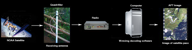
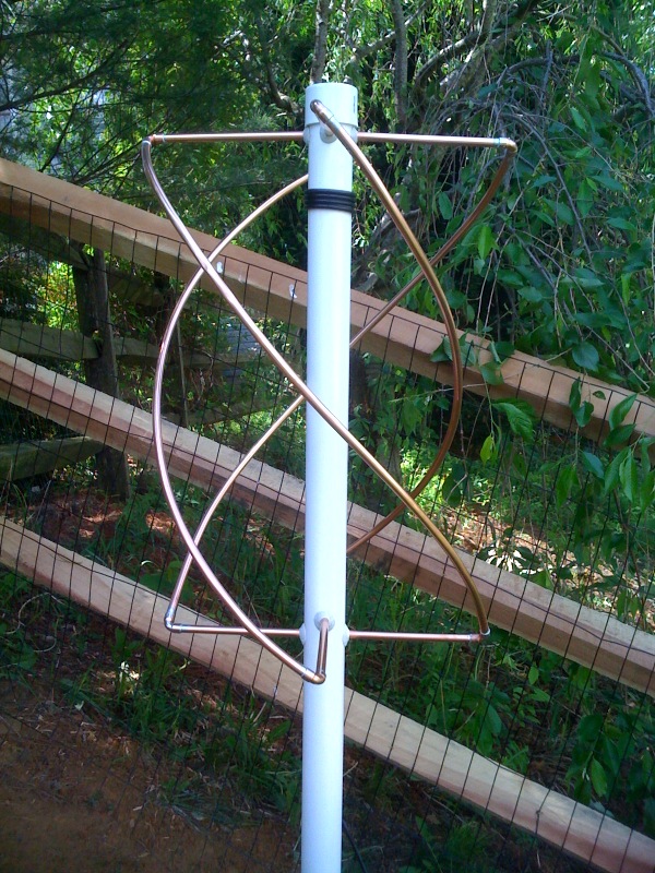
How Weather Satellite images are decoded

EQP

www.web-candy.co.uk


About the Enhancements

This page shows just some of the 35 enhancements WXtoImg provides:

MSA

Multi-Spectral Analysis: combines a sensor 1 or 2 (visible/near infrared) image with a sensor 4 (thermal infrared) image to create a near true colour, near visible image of the earth.

MCIR-precip

Map Coloured IR with Precip: uses sensor 4 (thermal infrared) to create a false coloured image showing areas of likely precipitation. The likelihood and intensity of precipitation increases as the colour goes from green to yellow to orange to red to black to white.

HVCT

HVCT false colour: creates a false coloured image by combining a sensor 1 or 2 (visible/near infrared) image with a sensor 4 image (thermal infrared) to create an image in which clouds are tinted by their temperature.
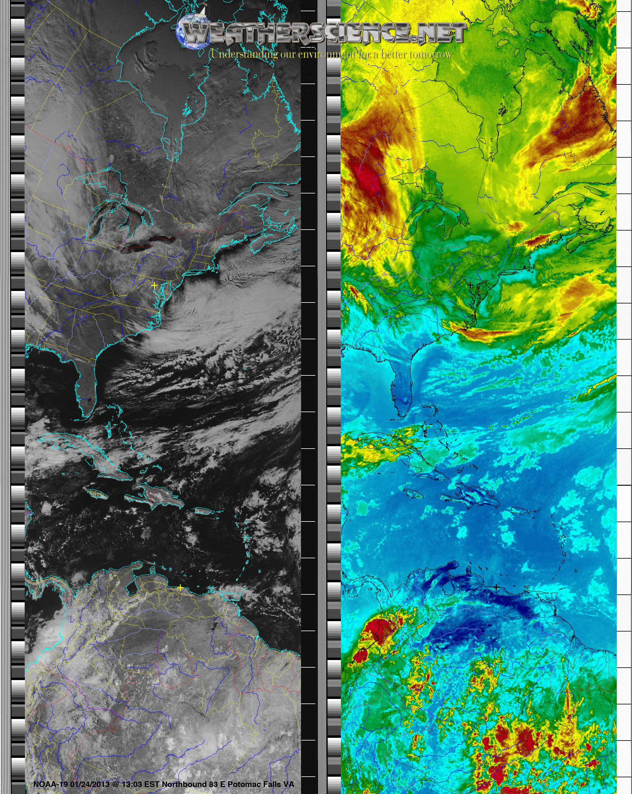
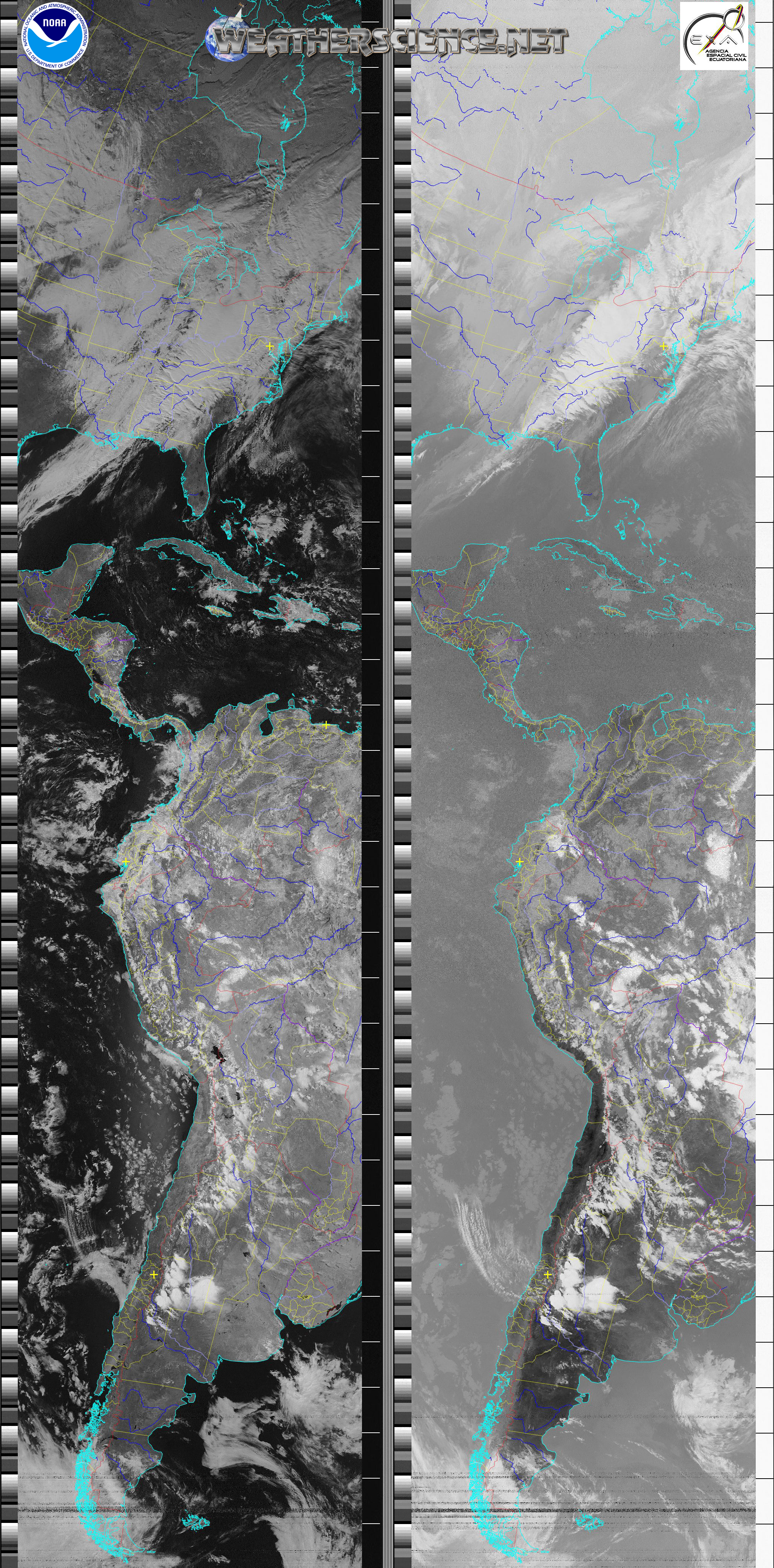
Pristine

These are images as they come from the satellite without alteration. The earth appears "upside down" on Northbound passes. The two images are the two channels sent by the satellite with channel A (left) switching between sensor 1 (visible) or 2 (near-IR) during the day and sensor 3 (mid-IR) at night and channel B (right) showing sensor 4 (thermal-IR) at all times during normal operation.

Thermal Thermal: Creates false color images using the temperatures from (sensor 4) Thermai Infrared image. This sensor covers the full range temperatures from very cold cloud tops to very hot deserts.
SST Sea Surface Temperature: creates a false colour image by combining sensors 3 and 4 (Infrared) and using a pre-defined palette colour the image.

Super APT Images


Multistation composite image creating the worlds longest APT images.

Next Scheduled Satellite Passes over Linden VA, United States

Satellite
Name
Start of Pass Time Available Direction Maximum Elevation
Degrees (East or West)
Frequency
MHz
UTC Local Time* UTC Local Time*
NOAA 18 25 Apr 16:42 25 Apr 12:42 25 Apr 16:59 25 Apr 12:59 137.9125
NOAA 19 25 Apr 17:04 25 Apr 13:04 25 Apr 17:14 25 Apr 13:14 137.10
NOAA 18 25 Apr 18:24 25 Apr 14:24 25 Apr 18:35 25 Apr 14:35 137.9125
NOAA 15 25 Apr 23:40 25 Apr 19:40 25 Apr 23:57 25 Apr 19:57 137.62
NOAA 19 26 Apr 01:06 25 Apr 21:06 26 Apr 01:36 25 Apr 21:36 137.10
NOAA 15 26 Apr 01:21 25 Apr 21:21 26 Apr 01:37 25 Apr 21:37 137.62
NOAA 18 26 Apr 02:26 25 Apr 22:26 26 Apr 02:43 25 Apr 22:43 137.9125
NOAA 19 26 Apr 02:47 25 Apr 22:47 26 Apr 03:03 25 Apr 23:03 137.10

* local time is Eastern Daylight Time.

Worldwide Satellite Image links provided by Laurent Thomin W0MM

North America South America
Europe
Asia
Africa
Oceania
Gorham, ME* LU2HAM, Colonia Caroya, Argentina*
Vasa, Finland*
Musashimurayama, Japan
Saint Pierre, La Réunion Isl.*
Swansea, NSW, Australia*
Northern Berkshire County, MA*
Villa Elisa, Argentina*
Högsjö, Sweden Tokushima, Japan
5Z4LA, Nairobi, Kenya
Bellmere, QLD, Australia*
Plymouth, MA
YV5DSL, Caracas, Venezuela*
Basingstoke, England, UK *
JQ2GLP, Hamamatsu, Japan
Canary Island
NH6YK, Pahala, HI
Richmond Hill, ON, Canada*
CA3SOC, Santiago, Chile*
Polmont, Scotland, UK*

VU2IIA, Mumbai, India, (no update)*

Le Tampon, La Réunion Isl.
Perth, Australia*
NF3V, Havertown, PA*
PY2MMK, Sao Paulo, Brazil*
Grootegast, Netherland
Suoi Tien, Vietnam*
Quatre Bornes, Mauritius Island*
Brisbane, Australia*
Tazewell, VA
Quito - Guayaquil, Ecuador*
OZ7OX, Hou, Denmark*
Kochi, Japan

Kumeu Astro. Obs. New Zealand*
Potomac Falls, VA*
Nimbus Weather, Uruguay
F2FT, Cassis, France
Tokyo, Japan

Coonabarabran, Australia
Fredericksburg, VA*
NP3OD, San Juan, Puerto Rico*
Mechelen, Belgium
Tokushima, Japan

Somerset, Tasmania, Australia*
Tobaccoville, NC
Mendiolaza, Argentina*
Moscow, Russia


Howlong, Australia
North Charleston, SC, USA   HB9AFZ, Bellinzona, Switzerland*      
Clear Lake, MN, USA   Bordeaux, France*      
Eau Claire, MI*   OH7FES, Lieksa, Finland      
KC9S, Sullivan, IL*

Fevik, Norway*


KA7OEI, West Jordan, UT*

EI2JP, Rosslare Strand, Ireland*


N8IMO, Gold Canyon, AZ

HA5KBF, Budapest, Hungary


W6BME, McKinleyville, CA

SQ1PSH, Szczecin, Poland (no update)*


San Francisco, CA*

IW2GOB, Lodi, Italy


WA6FWF, Newman, CA, USA*

SV2BZQ, Thessaloniki, Greece


Port Alberni, BC*

EA1JM, Salamanca, Spain*


Houston, TX*

OE8LWQ, Villach, Austria


HB9ZAG, Zürich, Switzerland*


* Pristine images available